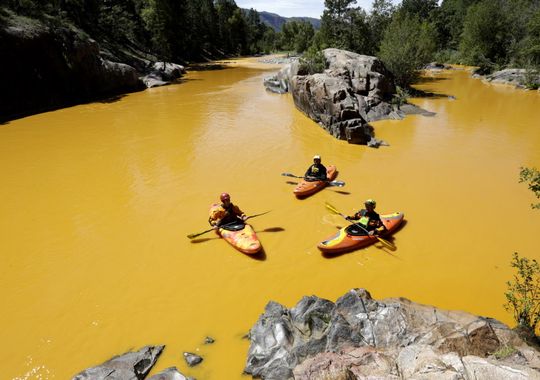
Animas River Aug. 6, 2015 (Photo: Jerry McBride, AP)
This past Wednesday, a team of EPA employees entered the Gold King Mine near Durango Colorado. According to CNN, instead of pumping and treating the wastewater within the mine, the EPA team accidentally released the contaminated water into the Animas River. As of Monday, the mine had released an estimated 3 million gallons and continued to discharge at a rate of 500 gallons per minute. The EPA waited almost a day to report the spill. Continue reading →
The U.S. Geological Survey and their predecessors have been providing topographic maps of the United States for over 125 years, and have worked to integrate new technologies into their practices along the way.
According to their official website, the U.S. Geological Survey, more commonly known as USGS, was established on March 3, 1879 through a bill signed at the end of the final Congressional session by President Hayes. Since then, USGS programs have focused on recording geologic data on all regions of the U.S. across many disciplines, with topography being one primary focus. USGS has provided topographic maps at varying scales, with the most familiar being the 1:24,000 or 7.5 minute quadrangle map. Throughout time, cartographers at USGS have migrated from hand-drawn maps pulled from field sketching in the late 1800s, to utilizing early electronic instrumentation in the mid-20th century, and are now able to create detailed maps using GIS.
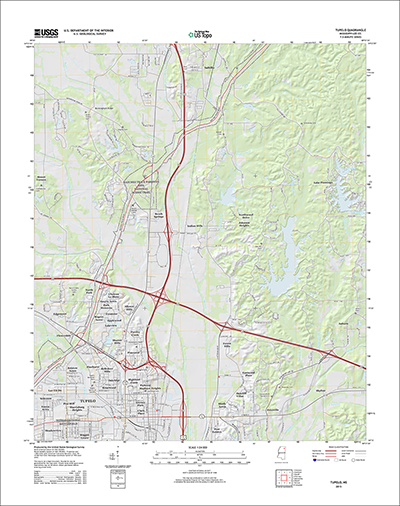
Sample Topographic Map from USGS.gov
This summer, USGS has debuted a new program, topoView, which offers unprecedented accessibility to these topographic maps, or topos, through an easy to use online interface. TopoView allows users to search topos from 1880-2010 anywhere in the U.S. using a sliding timeline bar and straightforward map of the country. Know the exact location you’re looking for, or scale you would prefer? You can also customize your search by entering that information in the respective search areas. If you encounter any issues along the way, USGS has conveniently provided an introductory video to walk you through the process here.
Hannah Weaver
Program Manager
Aerials & Environmental Research hweaver@banksinfo.com
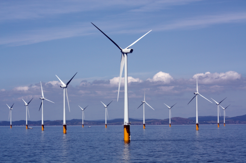
On Monday, July 27, Deepwater Wind took the first steps toward building North America’s first offshore wind farm.
Success in the Deepwater project may lead to larger North American offshore wind harnessing projects in the future.
Deepwater Wind will install the first five offshore North American turbines over the next year off the coast of Rhode Island. This initial build is intended to provide 30-megawatts of wind energy and will primarily serve as a power source for 17,000 nearby homes on Block Island and mainland communities.
While the offshore wind industry has been embraced by European countries, previous attempts at North American offshore wind farms have not yet been successful. This project is different from others in that it already has the backing of state and federal government officials as well as local residents, clearing both regulatory and community concerns more easily. Additionally, this project aims to install five turbines, whereas some previous attempts at reaching this first offshore milestone have aimed at projects with over 100 turbines. The more limited project scope has allowed for easier financing of this initial build.
As is often the case when discussing the wind energy industry, offshore wind farms have experienced opposition from conservationists. Concerns with the offshore wind farms include both whale and bird conservation. However, Deepwater has said it will “do the pile driving only when migrating whales are not in the area,” clearly aiming to ease these concerns.
Deepwater Wind and U.S. officials hope that this installation will be the first step towards expanding the offshore wind energy industry in the North Americas. Resulting larger projects may lead to opportunity for more cost-efficient production and energy capture. World leaders continue to have energy discussions and make commitments to goals of lower emissions. If this project is successful, North American officials may turn to the offshore wind industry as one part of the solution needed to meet these imminent goals.
To read more about the project, check out the articles linked below or visit Deepwater Wind’s Block Island project website.
This past March the Federal Bureau of Land Management (BLM) released new rules on hydraulic fracturing activities on federally managed lands. The BLM oversees and performs regulatory duties on around 700 million subsurface acres of federal mineral estates and 56 million acres of Indian mineral estates. The new rule aimed to review and update regulations of oil and gas development on public and tribal lands first established in the 1980s. BLM studied current state/tribal regulations, consulted with environmental experts, and reviewed 1.5 million public comments. According to the BLM press release the key components of the rule include the following:
Provisions for ensuring the protection of groundwater supplies by requiring a validation of well integrity and strong cement barriers between the wellbore and water zones through which the wellbore passes
Increased transparency by requiring companies to publicly disclose chemicals used in hydraulic fracturing to the Bureau of Land Management through the website FracFocus, within 30 days of completing fracturing operations
Higher standards for interim storage of recovered waste fluids from hydraulic fracturing to mitigate risks to air, water and wildlife
Measures to lower the risk of cross-well contamination with chemicals and fluids used in the fracturing operation, by requiring companies to submit more detailed information on the geology, depth, and location of preexisting wells to afford the BLM an opportunity to better evaluate and manage unique site characteristics
Environmental professionals often use Google Earth as an inexpensive way to view and analyze data. In February, we wrote about the relaunch of Google Earth Pro as a FREE program available to anybody with a computer. One of the key advantages to using the professional version, is that Google Earth Pro can import huge tables and place your information on the globe. Did I mention that it was FREE?
In this post I will teach you how to take latitude and longitude data from within an excel table and turn it into a placemark within Google Earth Pro. In addition, I will teach you how to save your points as a KMZ file for use in Google Earth. Continue reading →
Posted inGeomapping, GIS, Technology|Comments Off on How to map points from Excel in Google Earth Pro

 Meghan Juedeman