
 Whenever a water well is constructed, the driller is typically required to report details about the well on a driller’s log, or driller’s report. These logs include everything from date and depth drilled to location and lithology. Once the log is completed, it is submitted to the state environmental agency for processing. Sometimes state agencies will map these records. Otherwise it’s up to us to sleuth them out! After all, a well log is useless if you don’t know where the well is located.
Depending on the decade and regulatory requirements enforced by the state, the location data provided on well logs can vary greatly from log to log. Older logs often use grainy, xeroxed county maps from the 1960s with large X’s on them. Newer well logs may employ a variety of methods including street addresses and latitude/longitude coordinates. Knowing how to pick the most relevant location data can be difficult.
To decode a well’s location you must first go into it knowing that there will be some degree of ambiguity as to its true location. Since many older water well reports were scribbled on paper before the proliferation of computers, precise locations are a luxury.
In order to reduce this ambiguity as much as possible, we have compiled a checklist. Start at 1 and move down the list, if you are unable to use the method identified. If any piece of the Driller’s logs disagrees then you should question where the well should be located. In general, well locations should be identified using the hierarchy below.
1. WELL ADDRESS
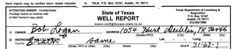
Water Well Log – Address
When a water well address is available on the driller’s log, check it out in Google Maps or Bing Maps to see if the address still exists. If the address doesn’t bring up any results, then that is a good indicator that you need to see if any additional information is available.
2. SITE MAP
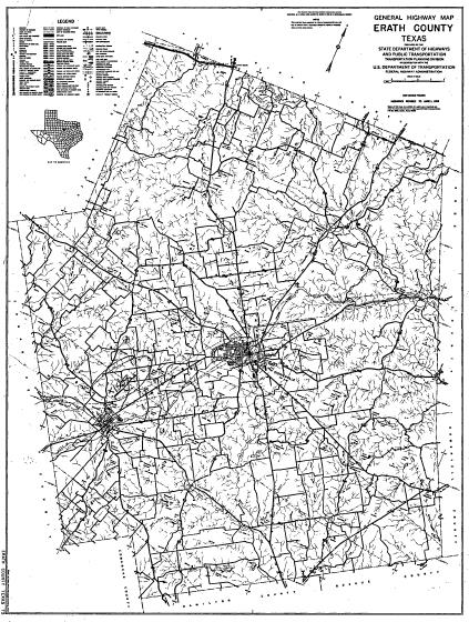
Water Well Log – Site Map
Site maps are both a blessing and a curse. These maps are often found in older logs and are generally printed on 8.5″ X 11″ standard printouts. If you’re lucky, the map will be a zoomed in version of a Key Map and will clearly depict the wells location with an X marks the spot. Most site maps, however, are a zoomed out highway map of the county with a very large X that marks the spot. It becomes difficult to determine location on these county maps because even a very small X can be the size of 4 city blocks.
3. ANYTHING ELSE
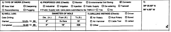
Water Well Log – Latitude and Longitude (right hand side of log)
If all else fails, look for latitude/longitude coordinates or a description indicating the well is a particular distance from two intersecting roads. Latitude/longitude values are mostly useless if recorded before 2000. Remember that each water well log is different. Methods that work for one particular well report may not be applicable to the next one.
Ian Holt
Program Manager – Water Wells
iholt@banksinfo.com