
 Image source: Reuters
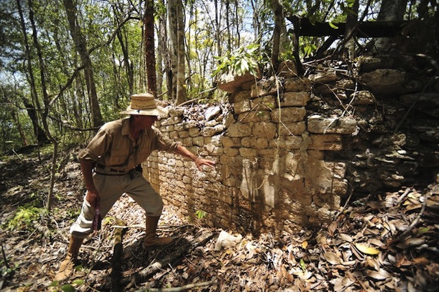
Ivan Sprajc and a team of archeologists from the National Institute of Anthropology and History (INAH) recently discovered ruins of a large Mayan city in southeastern Mexico. The 54-acre area is located in a remote jungle with dense vegetation that had previously only been penetrated by loggers and rubber tappers. Due to a history of limited accessibility in the area, the only feasible way to locate these ruins was by looking at aerial photos using stereoscopy.
“With aerial photographs examined stereoscopically, we found many features that were obviously architectural remains,” Sprajc explained in a announcement from INAH. “From there we took the coordinates, and the next step was to locate the ancient alleys used by tappers and loggers to reach the area.” The ruins have since been identified as one of the largest sites in the Central Lowlands. Understanding its relationship with other known cities nearby may prove useful in discovering the cause of the Mayan collapse.
Stereoscopy is a technique used by remote sensing analysts to transform a pair of aerial photos into a single three-dimensional image. This enables analysts to view depth within an image, which is ideal for measuring the heights of buildings or the topography of a mountain range. As an aircraft or satellite takes pictures along a path, features in each photo appear at a slightly different angle. There is considerable overlap between each photo in the sequence. When this overlap is aligned, the viewer is essentially seeing one area from two different angles.
The difference between those aspects is known as the parallax. By calculating the parallax, it is possible to determine the actual positioning of the feature as it appears on the earth’s surface – but a stereo viewer is required to properly view the images. Rather than two eyes coming together to view a single feature on a single photo, the stereo viewer directs both eyes straight-ahead so each one sees individually. The two successive photos are then set side-by-side under the stereo viewer and the common features in the photos are aligned. Viewing the features from two angles with two separate eyes causes a three-dimensional image to appear.
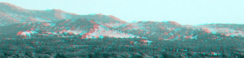 Image source: Wikipedia, Leonary G.
This technique proved useful to INAD archeologists because they were able to measure the heights of visible structures and deduce that some of them were as much as 75 feet tall. With visual evidence and height measurements of features like pyramids, ball courts, plazas, altars, and homes, they could virtually conclude that they were looking at the ruins of a large city.
Devon Canady
Aerials and Historical Mapping
dcanady@banksinfo.com