
Since we are once again in hurricane season, it seems like a good time to address how geospatial data and new data collection systems are shaping the way that we now interact with forces of nature. Although we have not yet experienced any major hurricanes this season, the lingering effects of hurricanes in past years are still present in many areas. Due to a new drone system, we may soon be able to learn more about hurricane patterns before they touch land.
This year Hurricane Edouard became an opportunity for scientist to test out a new technology – a drone called “Coyote” which measures variables such as water surface temperature, wind speed, and humidity. The seven pound Coyote flies at much lower altitudes than a manned aircraft and flies with the wind current. 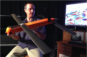 It is also equipped with retractable wings which can reach up to six feet long. The aircraft can be directed from a pilot several miles away for up to two hours. Although this was the Coyote’s first flight, scientists at the National Oceanic and Atmospheric Administration expect four more flights before the end of the hurricane season.
Before the advent of drones, small capsules with data collecting equipment and small parachutes attached were dropped from planes, but these devices have limited life-spans and are controlled only by the force of the wind.
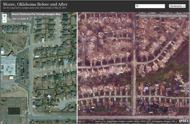
Additional developments in natural disaster mapping have been made with other types of natural disasters as well. In May 2013, FEMA put into action a new tool that could map areas devastated by tornados after a tornado tore through Moore, Oklahoma. FEMA originally began working on the system after a catastrophic tornado struck Joplin, Missouri in 2011. Various agencies worked together in Moore by using geospatial data to collect aerial imagery of the 17 mile long path carved out by the tornado. They created a base map of the most recent aerial imagery of the area before the tornado struck, along with information on population density and economic statistics.
Shortly after the tornado touched down, the Civil Air Patrol obtained aerial images showing the aftermath of the tornado’s path. They were then able to compare the before and after images. This provided first responders and emergency services professionals information about which areas were hit hardest and allowed them to prioritize services and address needs. Homeowners were also able to view and assess damages to their homes and property without putting themselves at risk or inhibiting emergency services.
Hazard mapping with geospatial data is not limited to weather, but can even be used to track wildfires. Using NMWatch, originally designed specifically for the state of New Mexico, citizens of California were able to track the King fire, which tore through northern California for almost a month starting on September 13, 2014. NMWatch is a collaborative system that tracks the progress of fire boundaries in an easy to use format designed for public use. Since there is no central fire information source, they gather their data from various agencies as well as social media sources such as twitter and blogs. NMWatch allows people to see fire boundaries in relation to themselves; much of the data layers are geared toward locals planners.
What is most impressive about these two systems, FEMA tornado mapping and NMWatch, is the speed at which they can be implemented. The FEMA team (working with the National Geospatial-Intelligence Agency) was able to deliver highly accurate geospatial damage assessments within four days of the event. NMWatch quickly updates fire boundaries based on the data provided to them. Increased access to information, and a better understanding of natural disasters may not be able to prevent them from happening in the future, but can lead to planning and preventive steps that could mitigate risk and possibly save lives in the future.
Sara Dunlap
GIS analyst
sdunlap@banksinfo.com
Sources:
www.livescience.com/47887-noaa-drone-tracks-hurricane.html
www.fema.gov/blog/2013-06-07/big-picture-role-mapping-assessing-disaster-damages
www.govtech.com/public-safety/NMWatch-Mapping-Fires-in-Collaborative-Fashion.html