
With the innovations in satellite and drone technology in recent years, procuring highly detailed aerials and topographic maps of a site is becoming easier than ever. Current, high-quality maps and imagery can be used to help farmers identify trouble spots on their land or property developers plan a new neighborhood. But what about all of the historical resources? In the United States, there are aerial photographs available for many areas as early as the 1920s. Topographic maps have a history as old as the country itself.
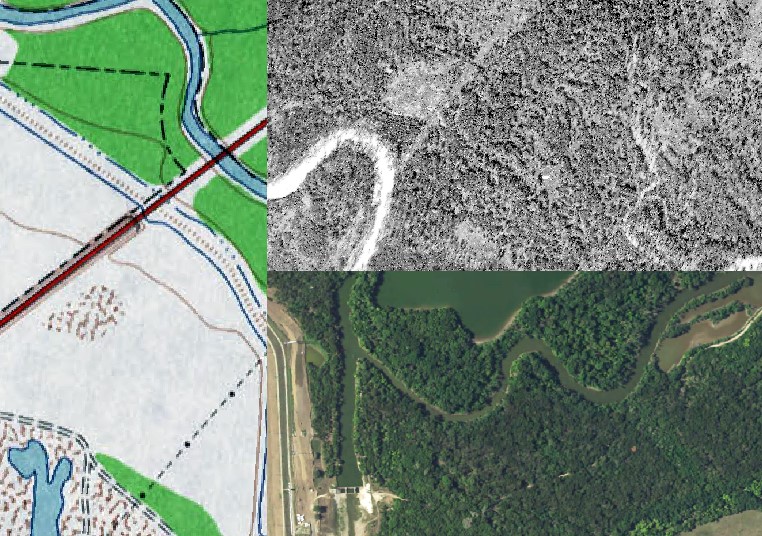
–Elm Fork of Trinity River in Irving, TX– Source: 1959 USGS Topo (Left), 1927 Fairchild Aerial (Top Right), 2014 USDA Aerial (Bottom Right)
The San Francisco Estuary Institute has put some of this historical data to work. According to the group’s website, SFEI was formed out of the former Aquatic Habitat Institute in 1993 with the intention of developing “programs that fit within the framework of a comprehensive monitoring and research program as envisioned by the CCMP.” The Comprehensive Conservation and Management Plan is a strategy created by the San Francisco Estuary Partnership aimed at evaluating the overall health of the San Francisco Bay, the Sacramento-San Joaquin Delta, and surrounding ecosystem.
One of the cornerstones of the SFEI plan is the restoration and reconstruction of this region through utilization of historical aerials, topographic maps, and other historical documents such as old journal entries found in explorer’s travel logs or even paintings. Through a slow and tedious process that can only be described as a labor of love, the group has already pieced together a good picture of how some of the water systems were originally laid out before humans altered the landscape. The goal is to understand the former configuration of these systems, which may not only provide a window to the past but a pathway to a future landscape that is more adaptable to climatic phenomena.
The New York Times recently reported on SFEI’s efforts along the Napa River, which has been transformed significantly since the early 1900s. Research has indicated that before the river was made deeper and more straight, floodwaters would absorb into surrounding tidal flats and marshes. After the river was adjusted, these marshes and tidal flats were filled in, and there was a notable increase in flooding of downtown Napa. Through a concerted collaborative application of resources, the reconstruction process has begun, and the Napa River region is being restored to something much more closely resembling its original layout.
Although ambitious, SFEI’s program is not the only example of historical maps and imagery being utilized to restore a landscape. The team behind the Welikia Project in New York City has produced an interactive map of the city created through dissection of old maps and various modern spatial analysis techniques that allows users to explore the city as it looked in 1609. On a smaller scale, the Country Club of North Carolina has even restored one of their championship golf courses to resemble the original design using historical aerials.
With the ever-changing landscape in the US and around the world, there are countless opportunities to restore and reconstruct ecosystems. With the vast number of historical resources available, doing a little digging into the past may be the perfect place to start planning for the future.
Hannah Weaver
Program Manager- Aerials and Environmental Research
hweaver@banksinfo.com0