
 In the United States, roughly 40% of the land, or 915 million acres, is dedicated to farming. That land provides an estimated 32% of the corn, 50% of the soybeans, and 30% of the cotton for the planet, according to reports from the EPA and USDA. The progression towards more efficient, accurate farming practices will benefit not only our domestic economy, but the supply of crops globally.
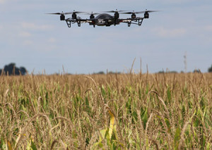
An Idaho company, Empire Unmanned, has been granted the thirteenth commercial drone exemption in the country, and the first for agriculture. Steve Edgar, founder of the company, has already put this to good use on the fifteen-acre Bitner Vineyards to help owner Ron Bitner pinpoint areas of crop stress on his land. “We still have to be in the field, but the ability to identify specific areas of the field that just need certain treatments really cuts down on applications of chemicals and work,” reports Edgar.
Edgar isn’t the only one looking for different drone applications in agriculture, though. With the ongoing drought in California, many agricultural professionals at an annual conference in Paso Robles, California, are looking for new, more efficient ways to pinpoint issues on their large parcels of land. Tiffany Holmes illustrates this at the conference, saying “If you have a spot on a ranch that maybe you can’t get to with a vehicle, you can set up a drone and have it fly over and see stuff…For large cattle ranches being able to see watering holes… I think it would be useful for them.”
Until the FAA releases their commercial guidelines on agricultural use, farmers are able to use drones as hobbyists under a special distinction in their current guidelines. When they do finally publish their commercial use regulations, chances are the applications for drone use on the farm will only increase. Until then, we will likely see more exemptions granted, as Edgar’s company received, and popularity increase. Follow the link below to watch a video from Science Daily for more on this topic.
http://www.sciencedaily.com/videos/68ec67f9eaac57b14ba48abc436689e5.htm
Hannah Weaver
Program Manager
Aerials and Historic Maps
hweaver@banksinfo.com